Incas knew five hundred years ago that the Amazon River originates in Peru
Rio Amazonas
When they established, in 2007, that the Amazon is the longest river in the world, based on expedition, GPS markings and satellite images, Brazilian and Peruvian scientists reaffirmed a truth that the Andean indigenous people had known for more than five centuries: it’s actually formed by the Ucayali River, not the Tunguragua. This finding makes it longer than the Nile. But it was already hidden, all these centuries, in the names of these two rivers.
In an impressive research presented in 1889 (LINK), the jurist João Mendes de Almeida demonstrated that Tunguragua comes from the Tupi Tange-yrê-áquá, which means “hurriedly runs after another”. And Ucayali is actually the corruption of Oquâ-uâ-ré, the one who “passes quickly and deftly ahead, leaving another behind”. This is because, despite rising further south than the Tunguragua, the Ucayali “runs faster” and meets it.
The source of both was also defined in the 18th century: it is Lake Lauricocha (Yâ-ri-qu’ógca, or “weave of crevices”, for its volcanic origin).
For those who rightly find these explanations in Tupi in the cradle of the Inca Empire strange, Almeida makes more revelations: the name Peru comes from Pé-rú, which in Tupi means “has a way”, in a reference to the road that crossed the Andes – which in turn comes from A’-ndi, or “many peaks”. The “Tupi people” were the “first generation” of the Americas, concludes the scholar, after other etymological references that reach as far as Mexico.
The names – or ignorance about them – had geopolitical implications that shortened the Amazon River. The Portuguese did not allow the Marañon River, of which the Tunguragua is a tributary, and which descends the Andes, to reach Brazil with that name, believing in the legend that it came from a supposed Spanish captain who would have discovered it. In fact, its name comes from Maran-nhã, in Tupi, which means “runs unreasonably”.
All these confusions stem from how unlikely the Amazon is. Its source is very close to the Pacific Ocean, at 5,300 meters of altitude, in a dry and cold peak. There, it begins as a squalid sheet of water, which in no way resembles the Parà-nà-guaçú, “similar to the big sea”, as the Indians called it.
Before choosing his path, he hesitates. It generally runs in a south-north direction, and even draws a curve to the north-northwest, as if intending to take the shortest route. Then, in a strait called Pongo de Manseriche, which it crosses greedily, it turns sharply to the east. And it embarks on the longest journey of a river on Earth: at least 6,850 km (the Nile has 6,670), until it empties on the other side of the continent.
In fact, the Amazon was born violent when it descended from the Peruvian Altiplano, changing its name over and over on its way. When it reaches the plain, it completely changes its rhythm. From Benjamin Constant, on the border with Peru, to the Atlantic, the river descends only 65 meters, crossing 3,220 km of Brazilian territory – which gives an average gradient of 20 millimeters per kilometer. Hence its average speed is only 2.5 km per hour.
Along the way, the immense river and its more than 7,000 tributaries become the food, the road, the home, the way of life for millions of people who inhabit its 5,846,100 km2 basin, the largest in the world.
Colombia hastily calls the Amazon River (which gives its name to the Department through which it passes, demarcating the country’s border with Peru and Brazil) which, upon entering Brazil, becomes just an arm of the Brazilian Amazon: the Solimões . Only 1,620 km away – 10 km after Manaus – is the Solimões named Amazonas, when it meets the Rio Negro.
Not without reluctance. The cold and whitish water of the sluggish Solimões, full of sediments that its tributaries have been bringing from the Andes, and that increase with the countless floodplains that submerge it, takes 6 km to start mixing with that of the Negro, acid, hot, fast and much shallower (30 to 35 meters deep, while Solimões reaches 80 meters).
From Manaus to Belém, it becomes the most important waterway in Brazil, with 62% of the cargo transported in the country. Along its 1,650 km, products from the Free Zone are transported and their components, grains from the Madeira River and bauxite from the Trombetas arrive, in addition to supplying the entire region. With a depth of 30 to 40 meters, the river is navigable throughout the year by large ships.
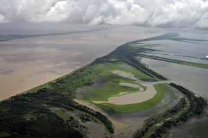
From one shore you can’t see the other. With the exception of the estuary (where it flows into the sea), its widest section is near the mouth of the Xingu River, with 13 km. But during the floods, when it rises up to 13 meters, its width can exceed 50 km.
The flow of the Amazon was calculated in June 1963 by the U.S. Geological Survey at 216,342 cubic meters per second. The calculation was made at the height of Óbidos (PA), where it crosses its narrowest “throat”, 2,600 meters wide. Below this city, it still receives water from important tributaries, such as the Tapajós, the Xingu, the Pará and the Jari.
In 1500, the Spanish navigator Vicente Pinzón, considered its discoverer, called it Mar Dulce, before his compatriot Francisco Orellana associated it with the Greek myth of the Amazons.
Upon reaching the Atlantic, the Amazon River faces it as if it really believed it to be a “big sea”, opening into a mouth 320 km wide. It releases into the ocean the equivalent of 11% of the entire mass of continental water in the world. Its fresh and muddy waters violently push those of the sea for up to 200 km, and this tumultuous encounter forms waves up to 5 meters high. A terrifying spectacle, with a sweet name: pororoca, which simply means “bang”.
(Text by Lourival Sant’Anna, originally published in Estadão. Copyright: Estadão.)
Leave a comment